
the mapping software enabling modern local council management

Parish Online is an essential tool for simply viewing and printing maps, all the way to storing asset registers, producing neighbourhood plans and engaging with the public
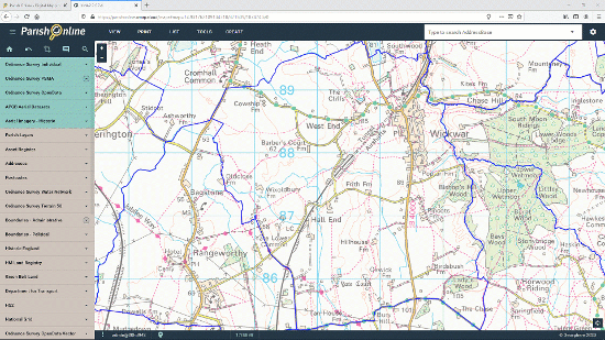
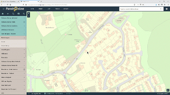
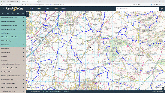
View Maps
With over 100 Map Layers pre-loaded and kept up-to-date, you'll be able to gain a greater understanding of your area.
The map layers included are chosen to help users with the most common council tasks. Whether you're finding something specific like an SSSI, or simply understanding the geography of your area, Parish Online is a fantastic source of information.
Layers such as parish boundaries, addresses, listed buildings and flood zones are regularly used by Parish Online users for day-to-day management tasks. Use Parish Online on your own computer, or project it onto a screen during a meeting to engage your audience.
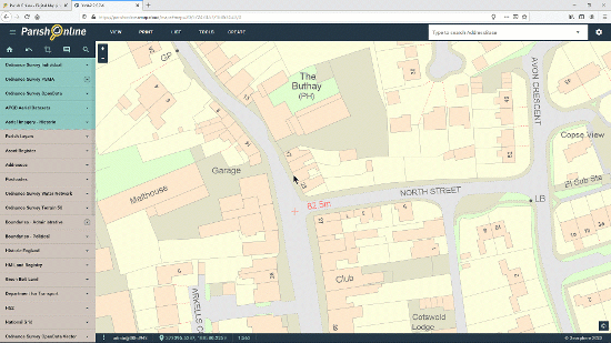
Info Click
All digital maps have information stored within them. This is what makes digital maps more than just a pretty picture.
Click on any feature to display the information stored within it. Whether it's something you've drawn, or a feature from one of the many layers available in Parish Online, you can click on them to show that information as well as coordinates, distance, perimeter and area measurements.
Wherever you click on the map, Parish Online will return all the information on the features it finds. View that information on the left-hand panel.
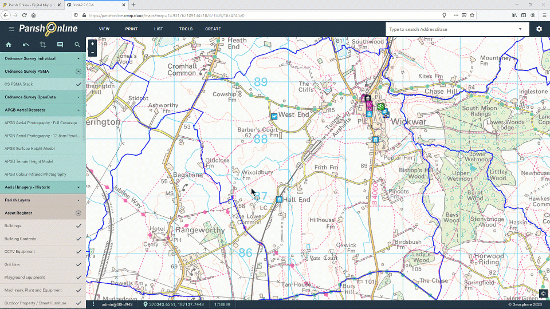
Create Map Layers
Create permanent, informative Map Layers to build up a picture of your area, with no storage limits.
Create point, line or area Map Layers to store information on topics that are important to your local council; e.g. grass cutting areas or owned land. These layers are securely stored within your Parish Online account and can be accessed 24/7.
Using Map Layers provides the council with a permanent and secure record of assets and maps accessible to all authorised staff.
Each map feature can contain additional text, measurements and attachments to ensure knowledge is saved for current and successive clerks and councillors.
Style Layers
The styling tool gives you the ability to create dynamic styling for each of your layers.
When working with lots of different map layers it's important to give them distinctive and intuitive styles. The styling tool makes this a quick and easy process.
Styles within a Map Layer can be the same for all features, or they can change depending on the classification of a feature. For example, you can show grit bins with a green icon if they are full, orange if they are half-full and red if they are empty.
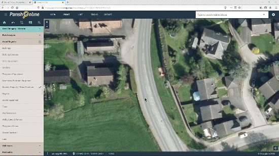
Manage Assets
Use Parish Online as a repository for your council assets, ensuring you have an accurate and up-to-date asset register for your Insurance policy.
The pre-formatted Asset Register layers make it easy to add anything you own, from a printer, to a playground, to a town hall. Each pre-formatted layer has text fields to prompt you to add essential information that your insurance provider can use to help you with claims.
Having an online record will save time and quibbles if a claim needs to be raised.

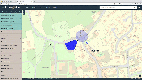
Annotate Maps
The annotate tool allows you to mark-up the map to highlight issues or communicate ideas.
The annotate tool has point, line, arrow, area, circle and label options to give you complete flexibility in marking up the map. However, the annotate tool should not be used to store permanent data - it's only there to highlight information on a temporary basis.
Need to share an issue? Mark up the map then use the print tool to send a PDF to a colleague.
Print Maps
A picture is worth a thousand words! It's easy to create professional and informative maps to communicate issues with your colleagues or to publish maps for a Neighbourhood Plan.
Unlimited use of the print tool means there's more opportunity to use maps as part of your work.
The print tool has pre-formatted templates, paper size and scale options so it's quick and easy to make high quality maps.
Unlimited use of the print tool means there's more opportunity to use maps as part of your work.
The print tool has pre-formatted templates, paper size and scale options so it's quick and easy to make high quality maps.
Export Information
Extract data for specific areas to use in tasks such as address mailshots or building evidence for a Neighbourhood Plan.
You can export information from any chosen layer such as Listed Buildings or Addresses. You define the extent of the export by choosing your parish boundary or drawing an area using the annotate tool.
Data is extracted to a CSV file which is compatible with Excel and other spreadsheet software.
You can export information from any chosen layer such as Listed Buildings or Addresses. You define the extent of the export by choosing your parish boundary or drawing an area using the annotate tool.
Data is extracted to a CSV file which is compatible with Excel and other spreadsheet software.
Collaborate
Create additional user accounts for colleagues or consultants.
User accounts allow a clerk to share responsibilities with councillors, neighbourhood plan groups, volunteers or consultants.
Accounts can be set to limit the user's ability to view and edit data. This ensures that data can only be edited by chosen users.
User accounts allow a clerk to share responsibilities with councillors, neighbourhood plan groups, volunteers or consultants.
Accounts can be set to limit the user's ability to view and edit data. This ensures that data can only be edited by chosen users.
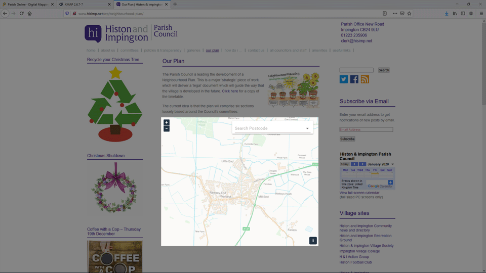
Publish Interactive Maps
Publish interactive maps on your website to showcase information and engage with the public.
Use this tool to create embeddable maps for your website which can be viewed and searched by the public. You can limit the amount of information that's shared in each interactive map.
They can be used for showing walking routes, playgrounds or upcoming events, for example. Public Maps are easy to create and generate the code you need to add them into your website.
View Maps
With over 100 Map Layers pre-loaded and kept up-to-date, you'll be able to gain a greater understanding of your area.
The map layers included are chosen to help users with the most common council tasks. Whether you're finding something specific like an SSSI, or simply understanding the geography of your area, Parish Online is a fantastic source of information.
Layers such as parish boundaries, addresses, listed buildings and flood zones are regularly used by Parish Online users for day-to-day management tasks. Use Parish Online on your own computer, or project it onto a screen during a meeting to engage your audience.
The map layers included are chosen to help users with the most common council tasks. Whether you're finding something specific like an SSSI, or simply understanding the geography of your area, Parish Online is a fantastic source of information.
Layers such as parish boundaries, addresses, listed buildings and flood zones are regularly used by Parish Online users for day-to-day management tasks. Use Parish Online on your own computer, or project it onto a screen during a meeting to engage your audience.
Info Click
All digital maps have information stored within them. This is what makes digital maps more than just a pretty picture.
Click on any feature to display the information stored within it. Whether it's something you've drawn, or a feature from one of the many layers available in Parish Online, you can click on them to show that information as well as coordinates, distance, perimeter and area measurements.
Wherever you click on the map, Parish Online will return all the information on the features it finds. View that information on the left-hand panel.
Click on any feature to display the information stored within it. Whether it's something you've drawn, or a feature from one of the many layers available in Parish Online, you can click on them to show that information as well as coordinates, distance, perimeter and area measurements.
Wherever you click on the map, Parish Online will return all the information on the features it finds. View that information on the left-hand panel.
Create Map Layers
Create permanent, informative Map Layers to build up a picture of your area, with no storage limits.
Create point, line or area Map Layers to store information on topics that are important to your local council; e.g. grass cutting areas or owned land. These layers are securely stored within your Parish Online account and can be accessed 24/7.
Using Map Layers provides the council with a permanent and secure record of assets and maps accessible to all authorised staff.
Each map feature can contain additional text, measurements and attachments to ensure knowledge is saved for current and successive clerks and councillors.
Create point, line or area Map Layers to store information on topics that are important to your local council; e.g. grass cutting areas or owned land. These layers are securely stored within your Parish Online account and can be accessed 24/7.
Using Map Layers provides the council with a permanent and secure record of assets and maps accessible to all authorised staff.
Each map feature can contain additional text, measurements and attachments to ensure knowledge is saved for current and successive clerks and councillors.
Style Layers
The styling tool gives you the ability to create dynamic styling for each of your layers.
When working with lots of different map layers it's important to give them distinctive and intuitive styles. The styling tool makes this a quick and easy process.
Styles within a Map Layer can be the same for all features, or they can change depending on the classification of a feature. For example, you can show grit bins with a green icon if they are full, orange if they are half-full and red if they are empty.
When working with lots of different map layers it's important to give them distinctive and intuitive styles. The styling tool makes this a quick and easy process.
Styles within a Map Layer can be the same for all features, or they can change depending on the classification of a feature. For example, you can show grit bins with a green icon if they are full, orange if they are half-full and red if they are empty.
Manage Assets
Use Parish Online as a repository for your council assets, ensuring you have an accurate and up-to-date asset register for your Insurance policy.
The pre-formatted Asset Register layers make it easy to add anything you own, from a printer, to a playground, to a town hall. Each pre-formatted layer has text fields to prompt you to add essential information that your insurance provider can use to help you with claims.
Having an online record will save time and quibbles if a claim needs to be raised.
The pre-formatted Asset Register layers make it easy to add anything you own, from a printer, to a playground, to a town hall. Each pre-formatted layer has text fields to prompt you to add essential information that your insurance provider can use to help you with claims.
Having an online record will save time and quibbles if a claim needs to be raised.
Annotate Maps
The annotate tool allows you to mark-up the map to highlight issues or communicate ideas.
The annotate tool has point, line, arrow, area, circle and label options to give you complete flexibility in marking up the map. However, the annotate tool should not be used to store permanent data - it's only there to highlight information on a temporary basis.
Need to share an issue? Mark up the map then use the print tool to send a PDF to a colleague.
The annotate tool has point, line, arrow, area, circle and label options to give you complete flexibility in marking up the map. However, the annotate tool should not be used to store permanent data - it's only there to highlight information on a temporary basis.
Need to share an issue? Mark up the map then use the print tool to send a PDF to a colleague.
Print Maps
A picture is worth a thousand words! It's easy to create professional and informative maps to communicate issues with your colleagues or to publish maps for a Neighbourhood Plan.
Unlimited use of the print tool means there's more opportunity to use maps as part of your work.
The print tool has pre-formatted templates, paper size and scale options so it's quick and easy to make high quality maps.
Unlimited use of the print tool means there's more opportunity to use maps as part of your work.
The print tool has pre-formatted templates, paper size and scale options so it's quick and easy to make high quality maps.
Export Information
Extract data for specific areas to use in tasks such as address mailshots or building evidence for a Neighbourhood Plan.
You can export information from any chosen layer such as Listed Buildings or Addresses. You define the extent of the export by choosing your parish boundary or drawing an area using the annotate tool.
Data is extracted to a CSV file which is compatible with Excel and other spreadsheet software.
You can export information from any chosen layer such as Listed Buildings or Addresses. You define the extent of the export by choosing your parish boundary or drawing an area using the annotate tool.
Data is extracted to a CSV file which is compatible with Excel and other spreadsheet software.
Collaborate
Create additional user accounts for colleagues or consultants.
User accounts allow a clerk to share responsibilities with councillors, neighbourhood plan groups, volunteers or consultants.
Accounts can be set to limit the user's ability to view and edit data. This ensures that data can only be edited by chosen users.
User accounts allow a clerk to share responsibilities with councillors, neighbourhood plan groups, volunteers or consultants.
Accounts can be set to limit the user's ability to view and edit data. This ensures that data can only be edited by chosen users.
Publish Interactive Maps
COMING SOON! Publish interactive maps on your website to showcase information and engage with the public.
Use this tool to create embeddable maps for your website which can be viewed and searched by the public. You can limit the amount of information that's shared in each interactive map.
They can be used for showing walking routes, playgrounds or upcoming events, for example. Public Maps are easy to create and generate the code you need to add them into your website.
Affordable Subscription
Our price-per-population model means Parish Online is affordable for Town, Parish or Community Councils of any size. Prices start from £30 per year, and the average is £120 per year.
No Installation
Parish Online works through your computer's Web Browser, do you don't need to install or configure anything. It's also optimised to work well on slower Internet Connections.
Friendly Support
We're on-hand to help you with every aspect of using digital maps. We have online tutorials, step-by-step guides, videos and email support to make sure Parish Online works for you.

NALC recognise the importance of using digital mapping as a way to run efficient and modern local councils
Trial now for a
30day free trial
- Try the fully-featured Parish Online Mapping and keep your data if you carry on with a full subscription.
- Once your trial has ended you have the option to switch to a full subscription or even take advantage of a Clear-funded subscription.
Subscribe now for a
10% Discount
- For new subscribers to Parish Online Mapping who want to get started straight away with no trial period.
- We'll give you this discount every year providing you keep a continuous subscription with Parish Online Mapping.
Free with Clear Councils Insurance
Free for 1 year
- New to Parish Online Mapping? Take out a policy with Clear Councils Insurance and get Parish Online Mapping free for 1 year!
- Don't worry if you already have a policy with another provider, you can get Parish Online Mapping if you commit to switching when your renewal is due.
- Terms and Conditions apply, contact Clear for details.